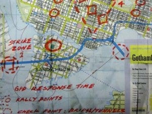
In one of the more unusual conspiracy theories to circulate online, several websites have pointed out a Gotham City map that both appears in The Dark Knight Rises and was part of a Warner Bros. promotional campaign. The Dark Knight Rises map lists the area of Sandy Hook as Strike Zone 1, which is also the name of the elementary school where a tragic mass shooting occurred last month.Now, the very same Dark Knight Rises map has led one school district to cancel classes and look at additional security precautions. According to WDBJ, Giles County Schools has delayed the return of students from Winter break by at least one day, because the Dark Knight Rises map includes another site called “Narrows.”As part of the delay of the start of school, the Giles County Schools superintendent issued a letter to parents, which noted, “On the evening of Dec. 27th, 2012, the Giles County Sheriff’s Department, the Town of Narrows police department, and the Giles County Schools, were notified by the Va. State police regarding information on a web-site. This web-site discussed the shootings that occurred at Sandy Hook Elementary in Newtown, Connecticut. Included in this discussion on the web-site was how “Sandy Hook” was referenced in the Batman movie “The Dark Knight Rising.” This reference was in a map that appeared in a scene in this movie. Another zone on this map appearing in the movie was “Narrows.” The author, who posted this article, did an online Google search based “on a hunch” for “Narrows Schools.” From this search, information for Narrows Elementary/Middle School and Narrows High School appeared.”The letter also noted that no specific threats had been made against any of the schools in Giles County, but that additional safeguards would be installed in the facilities.


